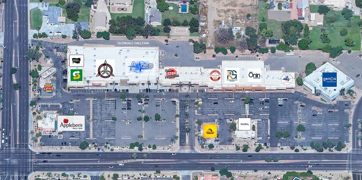
If you've spent any time putting together an offering memorandum or a lease proposal, you've encountered both retail maps and site plans. They often appear on consecutive pages of the same document, and at first glance they can look similar -- both are visual representations of a property and its surroundings. But they serve fundamentally different purposes, contain different information, and are created using different tools.
Understanding the distinction helps you decide which deliverable a given situation calls for, and how to produce each one efficiently.
What Is a Site Plan?
A site plan is a scaled, top-down drawing of a specific property or development. It shows the physical layout of the site itself:
- Building footprints - - the shape, size, and position of structures on the parcel
- Parking areas - - lot layout, drive aisles, parking counts
- Lot lines and setbacks - - property boundaries and required distances from those boundaries
- Access points - - driveways, curb cuts, ingress/egress locations
- Pad sites - - outparcel locations for freestanding buildings
- Square footage callouts - - the size of each unit or building
- Tenant names - - who occupies each space (for existing properties)
Site plans are typically produced by architects, civil engineers, or professional design firms. They're drawn to scale, often based on survey data, and may include dimensions, easements, and utility information. A well-drawn site plan answers the question: "What does this property look like, and how is the space organized?"
What Is a Retail Map?
A retail map zooms out. Instead of showing the internal layout of a single property, a retail map shows the surrounding commercial ecosystem -- the brands, stores, restaurants, and services in the broader trade area.
A retail map typically includes:
- Brand logos for major national and regional tenants within a defined radius
- The subject property highlighted or called out
- Major roads and highways with names and route numbers
- Category groupings - - restaurants, banks, grocery, fitness, etc.
- Leader lines connecting logos to their map locations
- Visual styling - - color schemes, map styles, and branding that match the marketing package
A retail map answers a different question: "Which reviewed nearby businesses and roads are being shown around the subject property?" Commercial viability requires separate market, financial, physical, and legal analysis.
When to Use Each
Site Plans Are Used When:
- A tenant needs to understand the physical space they're leasing -- unit size, entrance location, parking proximity
- An investor needs to evaluate the property's physical layout, density, and development potential
- A developer is planning construction and needs to show pad site locations or building orientation
- City planning or zoning review requires a scaled drawing of the proposed development
Retail Maps Are Used When:
- A tenant wants to know who else is in the area before committing to a lease
- An investor wants a visual of selected nearby-business context alongside separately sourced underwriting evidence
- A broker is marketing a listing and wants to demonstrate the property's strategic location relative to major brands
- A lease proposal includes a "trade area overview" or "surrounding retailers" section
In Practice, You Need Both
An offering memorandum may include both a site plan and a retail map when each is relevant. The site plan documents physical layout; the retail map presents selected surrounding context. Neither replaces the underlying property and market analysis.
How They're Created
Site plans are typically produced using CAD software (AutoCAD, Revit) or by professional drafting services. They require survey data and technical precision. Producing a site plan in-house without architectural training is difficult and generally not advisable -- errors in scale or dimensions create liability issues.
CRE Retail Maps combines searchable brand-artwork candidates, category-based nearby-business search with review and selection, leader lines, drag-to-group containers, and nine map styles. Pro users can download 2D PNG/JPG files up to 8000 pixels, 3D images up to 4096 pixels, or use one of five PDF layouts.
This distinction matters for workflow planning. Site plans are usually ordered from a vendor or sourced from the property's existing architectural files. Retail maps can be produced on demand by the broker or marketing coordinator, updated in real time as tenant mix changes, and customized for each pitch.
The Takeaway
Site plans and retail maps are not interchangeable. A site plan documents physical layout, while a retail map can present the subject location and selected nearby-business context.
If you're assembling an OM, include both. If you're putting together a quick pitch for a prospective tenant, a retail map can communicate surrounding context that a site plan does not. If you produce retail maps regularly, compare a dedicated editor with your manual or outsourced workflow using the same property and review standards.
Know the difference, use the right tool for each job, and your deliverables will speak for themselves.
Build your first retail map. Use the Free tier to build and preview a map. Downloads, including the five PDF layouts, require Pro.
Related guides
- Retail map software - What we do vs site plan tools
- All features - Every capability in the product
CRE Retail Maps Editorial Team
VerifiedCRE Software & Industry Analysis
The CRE Retail Maps editorial team produces in-depth analysis of commercial real estate technology, retail market trends, and broker workflows. Our content is reviewed by retail brokers and industry practitioners with decades of combined experience covering grocery-anchored, power center, and lifestyle retail across major US markets.