

The retail map page is often the most-viewed page in an Offering Memorandum. It's the page where investors and buyers immediately understand the property's retail context - who the neighboring tenants are, what the traffic patterns look like, and whether the location has the kind of co-tenancy that drives foot traffic and validates value.
A poorly designed map (a blurry Google Maps screenshot with logos crudely pasted in PowerPoint) undermines the credibility of the entire document. A professional map, on the other hand, signals that you've done your homework and that the property deserves serious consideration.
This tutorial walks through the complete process of building a retail map for an OM using CRE Retail Maps, from property search to final export.
Step 1: Set Your Property Location
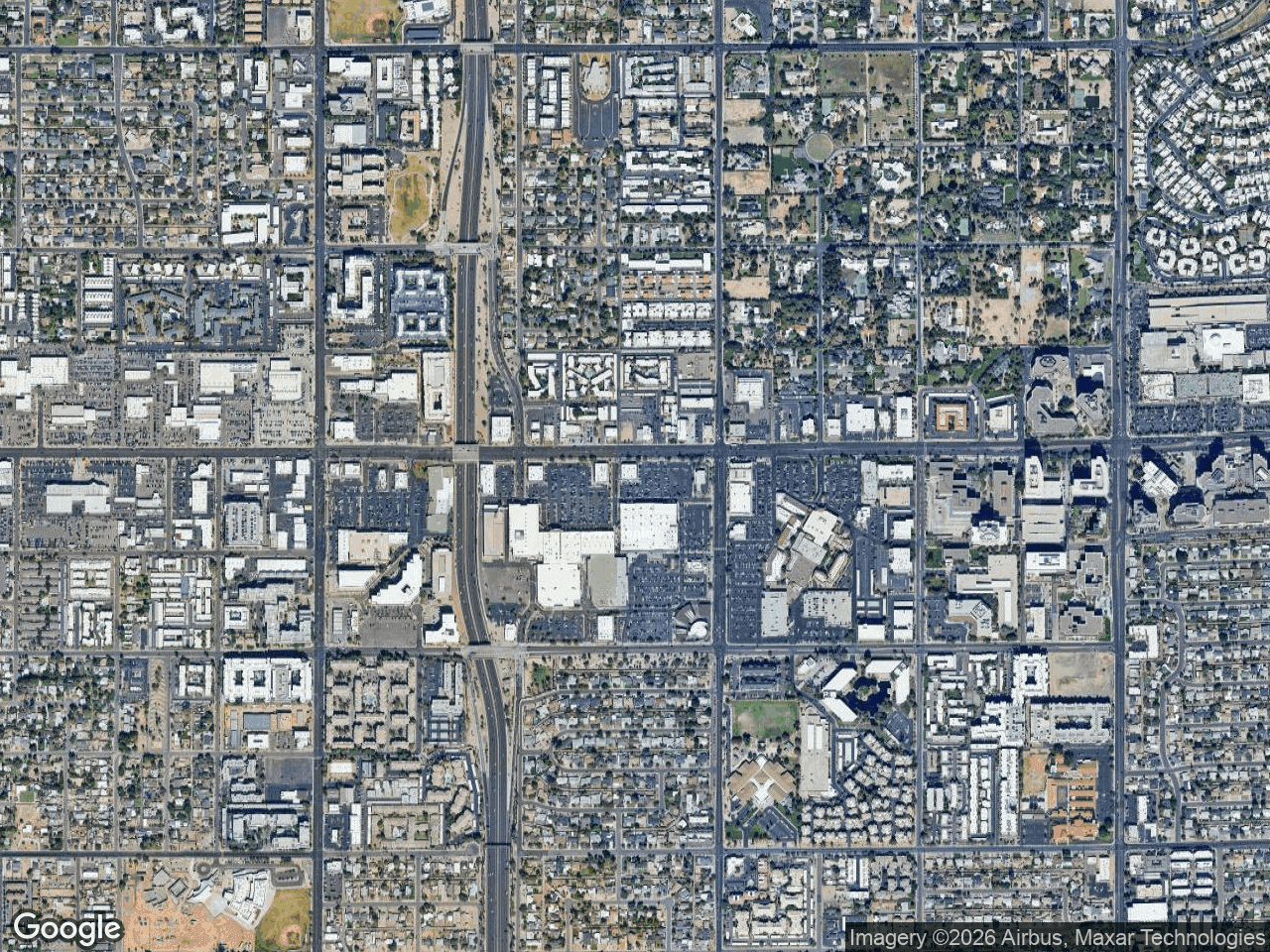
Open CRE Retail Maps and enter the subject property's address. The map automatically centers on the location and adjusts the zoom level to show the surrounding retail environment. You can fine-tune the zoom and pan to frame the exact area you want - typically a quarter-mile to half-mile radius around the subject property, depending on the density of the trade area.
For suburban properties with spread-out retail, zoom out to capture highway intersections and major shopping centers. For urban properties, zoom in tighter to show the immediate streetscape.
Step 2: Mark the Subject Property
Every OM map needs a clear "you are here" indicator. Place a subject property marker on your parcel - this creates a highlighted box with a "SUBJECT PROPERTY" label that immediately draws the viewer's eye. Position it precisely over the building footprint or parcel boundary.
Step 3: Add Anchor Tenants and National Brands
This is where the map starts telling a story. Use the brand logo search to find and place official logos for every significant tenant near your property. Start with the anchors - the Targets, Whole Foods, Home Depots - and work outward to smaller national tenants like Starbucks, Chipotle, and CVS.
Each logo gets placed on the map with a leader line - a clean dashed connector that runs from the logo to the tenant's actual location. Leader lines eliminate any ambiguity about where each business is relative to the subject property.
Step 4: Auto-Find Nearby Businesses
Don't stop at the tenants you already know about. Use the Auto-Find Nearby Businesses feature to search by category:
- Restaurants - Every dining option within your radius
- Banks - Chase, Wells Fargo, Bank of America locations
- Grocery - Supermarkets and specialty food stores
- Fitness - Gyms, yoga studios, fitness centers
- Coffee - Starbucks, Dunkin', local coffee shops
- Pharmacy - CVS, Walgreens, Rite Aid locations
The tool searches automatically and returns placeable results with official brand logos. This often surfaces tenants you didn't know were nearby - a discovery that can strengthen your OM narrative.
Step 5: Group Related Tenants
For denser areas with many nearby businesses, use drag-to-group containers to organize logos into labeled clusters. For example, create a container titled "Dining & Shops" and drag four or five restaurant logos into it. The container displays them in a clean grid layout with a header label.
Grouping keeps the map organized and prevents logo overlap in tight areas. It also creates a visual hierarchy - the viewer sees grouped categories rather than a scattered collection of individual logos.
Step 6: Style the Map
Now style the map to match your brokerage's brand identity:
- Map style: For OMs, Light or Silver work best. They provide geographic context without competing with the logos and leader lines.
- Brand colors: Set your brokerage's hex color using the custom color picker. This applies to containers, leader lines, and highlights.
- Highway highlighting: If highway visibility or access is a selling point, highlight the relevant roads with a colored overlay. Adjust weight and opacity to make it visible without overwhelming the map.
- Label controls: Turn off business labels (your placed logos replace this function). Keep street and highway labels on. Toggle area labels based on whether neighborhood names add value.
Step 7: Save POIs for Future Maps
If you frequently create maps in the same market, save your placed tenants to the POI Database. These saved points of interest persist across maps, so the next time you create an OM for a property in the same trade area, your tenant data is already there. This compounds your time savings across every deal.
Step 8: Export for the OM
CRE Retail Maps offers two export paths, and for an OM you'll likely want both:
- High-res PNG (up to 4K) - Use this if you're assembling the OM in InDesign, Canva, or another layout tool. The 4K resolution ensures the map stays sharp at any print size.
- PDF with branded template - Use this if the map will be a standalone page in the OM. The PDF template includes space for your brokerage logo, the property name and address, and the agent's contact information. It's ready to insert as a complete page.
Both formats preserve your styling - colors, labels, highway highlights, and map style all export exactly as they appear on screen.
Common Mistakes to Avoid
- Too many logos - A map with 30 logos becomes visual noise. Focus on the 10-15 most relevant tenants. Quality over quantity.
- Wrong zoom level - Too far out and the logos are tiny. Too close and you miss important context. Find the zoom that shows the relevant trade area without excessive dead space.
- Inconsistent branding - If every map you produce uses different colors and styles, it looks unprofessional. Set your brand preferences once and apply them consistently.
- Low resolution export - Always export at the highest resolution available. A pixelated map in a printed OM is an immediate credibility hit.
The Impact on Deal Flow
A well-crafted retail map doesn't just make the OM look better - it actively moves deals forward. Investors spend more time on pages with strong visuals. Tenants evaluating a space can instantly see the co-tenancy they're buying into. Lenders reviewing a loan package see a market that's been thoroughly analyzed.
The time investment is minimal: 10-15 minutes with CRE Retail Maps versus 1-3 hours with the PowerPoint-and-Google-Maps approach. And the output is dramatically more professional. For brokers who produce multiple OMs per month, that time savings and quality improvement compounds into a meaningful competitive advantage.
Related guides
- Retail maps for offering memorandums - The OM workflow explained
- Branded PDF templates - Ready-to-use template gallery
- Make a retail map fast - The 10-minute map workflow
CRE Retail Maps Editorial Team
VerifiedCRE Software & Industry Analysis
The CRE Retail Maps editorial team produces in-depth analysis of commercial real estate technology, retail market trends, and broker workflows. Our content is reviewed by retail brokers and industry practitioners with decades of combined experience covering grocery-anchored, power center, and lifestyle retail across major US markets.